Fast + Accurate Export Points with Dynamo
Civil 3D has long been a powerful solution for site civil design, but when it came to customization and efficiency, the options were limited. A couple years ago when you ran into the limits of what Civil 3D could do, you only had two options; pay for someone to write programs for you or write Lisp routines. Paying for programming services gets expensive quick and Lisp routines are limited and clunky in what they can do. Now sky is the limit with a third option that resets Civil 3D automation and customization -Dynamo!
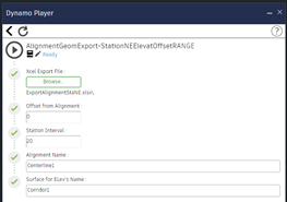
Dynamo is a relatively simple visual programming interface based on the Python language. You don’t actually know how to program, you can just search for your node of choice and put powerful scripts together. These scripts can then be disseminated to the entire design team for easy use through the Dynamo Player.
There is a learning curve to Dynamo, but once you put a little time in on the front end, you and your team can save hundreds of hours on the back end. Every project can be done more efficiently with a little Dynamo integration. If you can dream it, Dynamo can do it!
Here is an example.
CREATE POINTS OFFSET FROM AN ALIGNMENT AND EXPORT TO A CSV
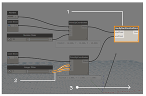
Creating offset points for the survey crew to stake out in the field can be tedious, time-consuming, and open for errors. The points must be manually created, grouped together, and exported to a format the stake-out surveyor can use. With Dynamo or Dynamo Player:
- Select the alignment
- Pick the offset distance to either side
- Hit Run
In the drawing the points get created and instantly exported to a csv ready to stake out!
Download the Dynamo Graph Here >
MG’s DYNAMO SERVICES
MG is an industry leader for Dynamo services for Civil 3D. We can be contracted to provide Civil 3D through Dynamo customization for organizations as well as training for designers looking to add Dynamo to their skillset to maximize their efficiency in Civil 3D.

At MG, Nick Turner brings his expertise within the Civil Engineering community. He trains surveyors, engineers and contractors across the nation on the latest design techniques. These include GIS to Civil 3D, Civil Infrastructure, Point Clouds, Virtual Construction, Hydraulic Design, Scanning, Lidar and 2D Hydraulic Modeling. He is a passionate, knowledgeable, committed and innovative individual.